Well, I have said it before and I will say it again: DCS is the best there is in terms of combat flight simulators.
With regards to the realism, the graphics, single and multiplayer options, aircraft, mods, and everything in between—DCS is unbeatable.
No comparison.
Of course, what makes DCS even better is the fact that it is not static. On the contrary, the DCS environment is thriving and the player community is vibrant and dynamic. Thousands of games run on hundreds of servers every day in countries all over the world.
In order to keep up with the expansion of its player base, DCS has been releasing maps at a steady rate. As of this moment, six maps exist in the DCS environment.
Of course, which maps are best for you will depend on a number of factors including your playing style. Although most of the maps include some mix of land versus sea, they come in different proportions. Some maps also feature more hilly terrain while others are rather flat.
In order to help you choose which maps are best for your playing style, we have ranked the six available maps and provided a brief description of each.
Don’t be mistaken though - all of the maps are good. Nevertheless, some are perhaps better than others.
Well, let’s get cracking…
6. DCS: Nevada Test and Training Range (49.99 USD)
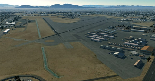
The Nevada Test and Training Range (NTTR) is one of the most valuable pieces of airspace “real estate” in existence anywhere in the world. This is where the Red Flag exercise—the USAF’s answer to the navy’s Top Gun program—takes place with international partners each year.
NTTR provides excellent flying country. Although flat desert plains take up much of the map, there are also complex networks of mountains and valleys. The area is home to numerous airfields, including Nellis Air Force Base and the infamous Groom Lake Air Force base—better known to UFO-enthusiasts as Area 51.
Due to its relative isolation from built-up areas, the Nevada grounds are home to many mock training systems, including simulated air defense positions and target ranges for bombing practice. The area was also the site of numerous nuclear tests until open-air nuclear tests were banned by an international treaty.
The NTTR map brings this prized piece of airspace and terrain into the DCS environment. In addition to the vast expanses of wilderness mentioned above, the map also includes a beautiful representation of the city of Las Vegas with full models of the hotels and casinos lining the famous Las Vegas Strip.
The map also includes a majestic recreation of Hoover Dam, one of the most iconic vistas of the American Midwest.
With many airfields to choose from, themap has become a popular choice for red versus blue air battles on DCS servers. Ground pounding is another popular pastime for players choosing this map.
Of course, the lack of any sizable body of water in the map means that it is not suitable for carrier operations. The Nevada desert is dry as a cracker.
What’s great about the Nevada Test and Training Range Map:
- Enjoy 366,000 sq. km of the most prized airspace in the entire world with accurate representations of airfields, terrain, cities, powerlines, and much more.
- Buzz the Las Vegas Strip at supersonic speed or take a peek at Area 51 from 50,000 feet—your choice.
- Enjoy rolling hills and wide open desert plains, including majestic views of Hoover Dam and Lake Mead.
- Join a server with your squadron and dogfight to the death above the desert wilderness.
5. DCS: The Channel (49.99 USD)
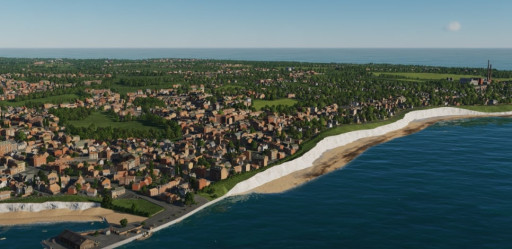
The Channel map is a no-brainer for DCS pilots that have WW2 era warbirds.
This one is a must-have for WW2 buffs. The English Channel was the site of history’s best known aerial battle—the Battle of Britain.
After Germany’s panzers rolled into Paris and the French surrendered, Britain was left alone in Europe. For the first time in almost a thousand years, the British Isles were at risk of invasion. German generals worked tirelessly to put together a plan to invade Britain and complete Hitler’s conquest of Europe.
However, there was one major hitch. Although the English Channel was rather narrow and on a clear day the Germans could see right across to England’s cliffy shores, it was still an obstacle that they had to cross and overcome.
German landing ships risked being overwhelmed by the Royal Navy and the RAF as they dashed across the narrow sea-lane. Under such conditions any German amphibious operation risked being pinned where it was most vulnerable.
In order to negate this threat, the German Luftwaffe was tasked with destroying the RAF as a precursor to Operation Sealion—the planned German invasion of Britain.
Thus, throughout the summer of 1940 the best of Britain and the best of Germany took part in life-or-death aerial duels above the channel and the southern English coast. At times it seemed that the RAF could take no more, but through sheer will and determination the RAF survived and secured victory in the Battle of Britain.
The planned German invasion was shelved indefinitely, never to be resurrected.
This DCS map brings to life the theater of the Battle of Britain in stunning detail. Iconic images such as the White Cliffs of Dover, the Seven Sisters, and the seaside towns of Folkestone and Calais—among others—are recreated with painstaking accuracy.
Fans of warbirds such as the Spitfire and the Bf-109 now have the opportunity to recreate the aerial battles above the channel and perhaps change the outcome of WW2.
What’s great about the Channel Map:
- Enjoy 40,000 square km of airspace above stunning vistas of the English coastline, the Channel and Northern France.
- Take in accurate representations of this warzone as it appeared on the eve of the Battle of Britain, including models of the Chain Home radar belt, RAF airfields, ports, and much more.
- Jump into a Spitfire and recreate the historic battles of that fateful summer of 1940. Alternatively, man a Bf-109 or FW-190 to experience the battle from the perspective of the German Luftwaffe.
- Take in stunning vistas of the White Cliffs of Dover, the Seven Sisters, and other marvels.
4. DCS: Normandy 1944 (44.99 USD)
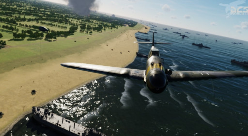
With changing seasons and fabulous views of the Norman coastline, this map is another favorite for WW2 buffs.
This map continues the WW2 theme in DCS and is ideal for players who are into warbirds from that era. The map models the situation immediately following the successful D-Day landings as Allied forces began to take over airfields in Northern France and adapt them to operations supporting their beachheads.
Various cities, towns and beaches are modeled in exquisite detail, including the concrete fortifications of the Atlantic Wall, the bocage fields of Normandy, and the French towns of Cherbourg, Caen, and Rouen, among others.
The map also supports changing seasons such that the vistas change to reflect blossoming springs and summers and white, snow-clad winters.
Step into a Spitfire cockpit and support Allied troops pinned on the beaches of Normandy. Or take a German Dora into the air and face off against endless waves of British and American bombers.
Alternatively, man a modern jet in clean configuration and treat yourself to aerial tours of the rolling fields of Northern France. Whether joyously clad in green, red, and yellow as the flowers blossom in Spring, or covered with a blanket of white snow, these aerial vistas are bound to make your day.
What’s great about the Normandy map:
- Enjoy more than 100,000 square km of prized airspace above Normandy, the Norman beaches, the Channel and southern England.
- Recreate the desperate air battles above the landing beaches of D-Day. Battle to the death in your Spitfire in turning fights against Luftwaffe Messerschmitts.
- Enjoy detailed recreations of quaint French seaside towns and the concrete bunkers of the Atlantic Wall as they appeared on the eve of the D-Day Landings.
- Witness the changing seasons and see the landscape of the map change from bright summers to cold and gray winters. Each are beautiful in their own ways.
3. DCS: South Atlantic (55.99 USD) - Early Access
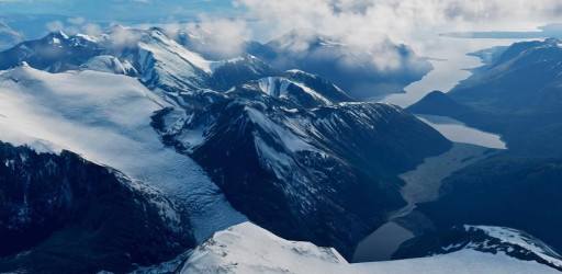
The South Atlantic map brings players amazing vistas and varied landscapes.
Covering more than 3 million square km of terrain, this map is huge and the largest DCS has seen so far.
This new map—still in Early Access—centers on the southern corner of Latin America. Accordingly, it covers the southern portions of Chile and Argentina, broad sweeps of the southern Atlantic Ocean as well as the Falklands Islands.
Accordingly, the map offers some of the most varied and beautiful terrain seen in any DCS map so far. This includes the icy peaks and glaciers of the Andes Mountains, the wide open plains of Patagonia, the chilly waters of the South Atlantic and the rugged, hilly terrain of the East and West Falkland Islands.
Don’t let the serenity fool you, the terrain and airspace featured in this map was the site of the Falklands War fought between Argentina and Britain in the early 1980s.
This brief yet violent conflict left a lasting mark on both nations and on aviation history. Although ultimately on the losing end, Argentine Naval Aviation dealt significant blows to British ships using Skyhawks and Exocet armed Super Etendards. Meanwhile, Fleet Air Arm and RAF Harriers flew off the decks of the HMS Invincible and the HMS Hermes to defend the British task force.
Recreations of these historic air battles were undoubtedly present in the minds of the developers of the South Atlantic map. Although still undergoing improvements as the map is in early access, several Argentine and British ground and naval assets are to be incorporated. These encompass ships from both sides and include the aircraft carriers HMS Invincible and the ARA Venticinco del Mayo.
What’s great about the South Atlantic map:
- Enjoy more than 3 million square km of mountains, valleys, fields, open seas, and islands. DCS players were consulted throughout the development process and aerial and satellite photography of the terrain were used as inspiration.
- Recreate the fateful aerial battles of the Falklands War. Jump into an Argentine Skyhawk and defend the islands from British navy ships looking to establish a beachhead. Alternatively, take off vertically in a Harrier and pursue Argentine attackers.
- In the mood for something more peaceful? Take a fast and nimble jet in clean configuration and zip and zoom along the glaciers and icy peaks of the Andes Mountains. Enjoy close-up aerial views of stunning mountain vistas and more.
2. DCS: Persian Gulf (49.99 USD)
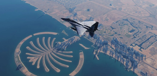
The Persian Gulf map centers on the Strait of Hormuz, a vital sealane and potential flashpoint.
Absolutely adored by the DCS Pilot community, this map delivers in all respects.
The Persian Gulf map is focused on the Strait of Hormuz. This narrow chokepoint is flanked by Iran to the north and America’s allies, the UAE and Oman, to the south.
Much of the world’s oil is shipped through this narrow sea-lane. Accordingly, the Strait of Hormuz has been a flashpoint for much of recent history and witnessed clashes between the USA and Iran during the 1980s “Tanker War”.
The map also includes vast swathes of the Arabian Sea as well as deserts and mountainous terrain. It also includes accurate reproductions of Dubai and Abu Dhabi with their iconic skyscrapers, in addition to other cities.
The mix of land and sea available in the map makes it ideal for both land-based operations from airfields in Arabia and Iran, or for carrier-borne operations from the Persian Gulf or the Arabian Sea.
What’s great about the Persian Gulf map:
- Enjoy 200,000 square km centered on the Strait of Hormuz—a strategic chokepoint for the world’s oil supply.
- Load the map with modern aircraft such as the Jf-17 or the Hornet and conduct exciting anti-shipping missions in the narrow corridor of heavily defended airspace above the Strait of Hormuz.
- Take a fast jet in clean configuration and do fly-bys meters away from Dubai’s iconic skyscrapers.
- Combine the map with the Supercarrier mod and conduct carrier-borne operations from the deck of a Nimitz class aircraft carrier from the Arabian Sea or the Persian Gulf.
1. DCS: Syria (59.99 USD)
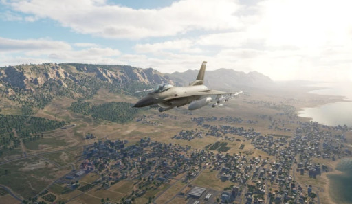
The Syria map is large and very popular among the player community.
Covering 450,000 square km of land and sea, this DCS map is a community favorite. Far from being limited to the state of Syria, the map also includes vast stretches of neighboring states such as Turkey, Lebanon, Jordan, and Iraq. This region has been host to many clashes between rival empires since the dawn of history and witnesses conflicts to the present day.
The Mediterranean island of Cyprus with its hilly interior is also included in the map, as are vast stretches of the Mediterranean Sea.
The map includes various terrains, ranging from the deep valleys and snowy peaks of the Lebanon and Anti-Lebanon mountains, to open desert wilderness and blue seas. The cities of Damascus, Beirut, Larnaca, and others are modeled to a high level of detail. Also included are more than 200 historical buildings which were drawn with a keen eye to detail.
DCS enthusiasts can benefit from dozens of military airfields, airstrips, and training ranges strewn throughout the map. When paired with legacy aircraft such as the A-4 and the MiG-21, the map allows players to recreate the historical air battles fought in the region between the Israeli Air Force and the Syrian Air Force.
What’s great about the Syria map:
- Players benefit from 200,000 square km of mixed terrain. From the icy peaks of Mount Lebanon, to the blue waters of the Mediterranean and the dry-as-a-bone Syrian desert, the map offers stunning vistas for all tastes.
- Enjoy beautiful and accurate representations of major cities such as Damascus, Beirut, and Acre among others. Historical buildings such as ancient monasteries and Roman ruins have also been recreated with painstaking attention to detail.
- Hop into an IAF Skyhawk or man a SAAF MiG-21 interceptor. Recreate the famous air battles that took place during the Arab-Israeli conflict and see which tactics or techniques could have altered the results of those battles.

